Thursday, September 29, 2011

Great Dismal Swamp Canal


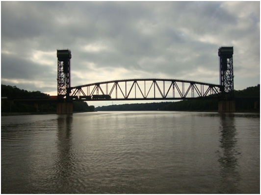
Yesterday, we did the sightseeing thing in Norfolk and had an enjoyable day. We did a small run on “The Tide” which is basically a 3 car transit train, from one end of the city to the other. When rounding one corner it looked like the Battleship USS Wisconsin was coming straight down the street at us. Man what an impressive sight.


These things are monsters as compared to the other destroyers. The Wisconsin was built and served in WW2, Korean War, Vietnam and was the first US Navy vessel to fire a cruise missile into Iraq during the Gulf War.
There is a nice museum here on the waterfront with tours of the ship.


This morning we got up early and departed Norfolk for the Great Dismal Swamp Canal……. Even though Jan would rather we went down the Virginia Cut, as it’s a little wider and much deeper. I on the other hand wanted to escape the never ending bridge openings and tug & barge traffic.

Well, as we passed the last bridge in the Elizabeth River, I saw a little brown sign pointing to the Great Dismal Swamp and made a hard right. I only recognized the sign because of Scott’s blog. So, before Jan had anything to say, I had swung the boat hard to starboard and into this very narrow area of swampland and continued down towards the locks. Boy was she mad…… but too late now….. it’s too narrow to turn around and we only had 0.5 feet of clearance under our keel.

Well, what a great decision this turned out to be. We arrived at the Deep Creek Locks a little early and had to anchor until they started to open to take us in. The lock operator was a fantastic tour guide.


As you can see, we’re about half way to Marathon with about 1100 miles to go. Told you it was a long trip.


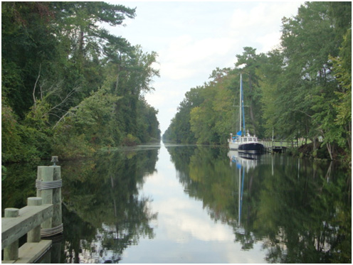
After clearing the lock we entered this magical kingdom called the Great Dismal Swamp Canal and followed it for 28 miles where we arrived at the North Carolina Visitors Center……. And they had wonderful docks right on the canal. We only had a few bumps on over saturated logs that had sunk to the bottom but generally had about 7-8 feet of water the entire way.


Oooops……. There’s another overhead branch of a tree that we nearly took out with the shrouds. Let me explain here folks…….. the canal is basically a cut ( that was supervised by George Washington and started in 1793 and completed in 1805. It was dug by hand by slaves.) through a swamp that is about 50 feet wide and 45 miles long. They call it “the ditch” because that is what it is.


The water is so tanic in colour that it stains the bow of the boat with the ICW Mustache.

However, this cut is very magical and beautiful. Today , it was in the mid 80’s and we enjoyed the sunshine.


So, as the sign says…… “WELCOME TO NORTH CAROLINA
We arrived at the visitors center about 2pm today and decided to stay the night with Dick & Kate Robinson who we basically followed all the way here. The dock is very nice and Jan can just step right off the boat and onto the dock. I went over to the visitor center on the other side of the pontoon bridge where the young lady described how an alligator was run over last week by a car and that there are cottonmouth rattlers in the woods, etc.

Jan’s afraid that something is going to crawl across the deck tonight and fall down through our hatch and onto the bed.

So, here we are at the dock at the Visitor Center. We had a nice supper at a picnic table beside the canal with more new friends, Dick and Kate.


Tomorrow morning we leave and run through the pontoon bridge and southern locks and may stop in Elizabeth City for the night.

Oh yeah……. Been through the Dismal Swamp and got the ball caps !!

Sept 30th- Dismal Swamp to Alligator River

Today was the best part of travelling so far. 80 degrees and sunny. This morning we left the Dismal Swamp Canal and headed down the last locks before heading down Turner’s Cut.


This part is absolutely breathtaking and far outways the dismal swamp section. The water, to Jan’s delight is about 14 ft deep and a bit wider. The wildlife was everywhere……. Turtles, snakes, birds, …. You name it and we saw it.

This is much more like motoring through a Cyprus swamp than we’ve seen so far. There is a constant layer of green swamp leaves and huge pines and Cyprus trees. We’re the only human beings for miles.


The whole family is here today!


Jan tried to run this poor guy down as it was swimming for it’s life…… probably could have killed you with one bite!

We passed under the bridge at Elizabeth City and as it was only noon we decided to cross Albemarle Sound and down to the Alligator River….. a distance of about 25 miles.

Tonight we’re at the Alligator River Marina and tomorrow it’s off to Moorehead City.

Wednesday, September 28, 2011

Mapping the Trip South


Click on the "View Larger Map" link to follow our trip South

Monday, September 26, 2011

Solomons to Norfolk


Man, I hate this internet service down here. Even though I have 4 bars here I still can’t get onto an internet connection. So I guess I’ll just have to load this onto a stick drive and find a library somewhere,

The trip down from Solomons to Deltaville was very easy but it was a long day. We saw our first pelicans of the trip…. About half a dozen of them and are they ever funny when they crash land in the water. They open up their mouth a bit and try to skim the surface but every single time the water catches them and they go head over heals into the water……. Really clumsy. They really do remind me of the pelican in Nemo.

As we made our approach to Deltaville we were greeted by two “flipper” type dolphins right at our bow as they jumped out of the water. They didn’t return to play in our bow wave.

The approach to Deltaville is extremely narrow but rather well marked and with the help of Dozier’s Waterway Guide which also shows aerial photos we made it in very easily.


We anchored just off Deltaville Marina and it was a very peaceful place. I thought I might walk up into the boat yard to check out the boat that Pat & Ted are looking at but couldn’t find it. There were about 50 boats neatly aligned in rows. I asked a guy why they were all hauled out of the water ane he told me that NO locals owned them. It was all people from around the great lakes, etc. They leave them there for the summer then return in Mid October, launch them and head south for the winter. He told me that in three weeks the place would be empty of boats……..

Sept 27th - Deltaville
That’s right folks, We’re in Norfolk now…land of the US Navy. Everything here is Navy right from the massive Naval Dockyard at the approach to the James River all the way to the entrance to the Elizabeth River and the Inter Coastal Waterway at Mile ZERO. We got fuel at Tidewater Marine right across from downtown Norfolk then went out of the marina to an anchorage with about 12 other boats swinging from the hook. As we approached our anchorage spot we saw that there was another identical boat to ours.
It belongs to Mike and Francie from Chicago who are also making the trip to the Bahamas.

Just after dropping the anchor and pouring our celebratory drink to cheer the weather Gods a couple pulled up in their tender and quickly announced that they were Ken and Merydie on Quick Sticks, a Bristol 29 out of Lahave River Yacht Club. We knew a lot of the same people. The name on their tender was “the twig”. How cute.


Well, all 4 came over for the evening and we had a great time.
This morning we’re going over to inspect the other Gulfstar 45.


See what I mean……. Nearly identical.

Like I said folks, Norfolk is all Navy. Here’s a few shots of some of the ships here.


USS ENTERPRISE – Doesn’t look like the one in Startrek


These two were in dry-dock.

Oh yeah…. And Garrett, you’ll love this one. As we were coming up the harbour we were met by this HUGE steel Transformer. He looked like he just wanted to bend down and scoop us up…. Hahaha


So, the Norfolk waterfront is rather pretty at night and Jan & I had a relaxing evening with new found friends. I don’t know how Jan is coping with all the stress


We’re staying here today to do a little sightseeing and some $4 appetizers at the marina, then heading out tomorrow morning.

Sunday, September 25, 2011

Solomons Island, Maryland


The other day…… and I have no idea what day it is anymore…… Jan says it was the day before yesterday, we left South River for Solomons Island. There was absolutely no wind or waves so it was motor again…… we’ve been motoring since we left Cape May due to lack of wind.
Well, the trip was very uneventful until we were about 10 miles from the turn towards Solomons when we heard this tremendous roar coming up behind us. It was a fleet of 50 foot, high speed racing boats doing as one of the drivers told me, about 130mph. …….. except for the “Miss Geico” racing team. This boat is amazing… twin jet engines in this 55 foot catamarin that sounds like a Boeing 767 taxiing down a runway. The rooster tail was about 20 feet in the air and there was a low flying helicopter right beside it doing the film thing. These boats were here for a Nascar on the water race and boy were they loud. Unfortunately I missed the pic with the helo because by the time I grabbed the camera they were passed us.
Gotta like the towing vehicle they have.


So, today was race day…….. and what happens when you try to round the very last buoy on the course at 180 miles per hour?????? LOOK OUT…… big splash as she flipped through the air. We saw them towing the boat into our marina……. As it was sinking……. with the owner on the bow hanging onto the tow rope. They hooked onto her with the slings ang got it out of the water quickly. Nobody was hurt.


After things calmed down I went for a stroll and found these terrific deals on sailboats for anyone with a good weed eater. Lane…. I think you’re looking for a new boat.


Today was a bit of a down day for us and we found a marina that charges only $1.00 per foot/night. This got us a marina, water & electricity, WIFI, laundry, showers and a pool and a courtesy car for 1 hour to get groceries, liquor, etc.

Not only was this a car…….. it was a black, diesel powered Mercedes Benze. It rode hard and nothing worked in the car but it served it’s purpose.
Tomorrow morning we’re heading south again for Deltaville, Virginia, about 50 miles down the coast and about 50 miles north of Norfolk, Va,
Now, some of the emails we receive are saying…”Is that as far as you’ve gotten??” WELLLLL…. For all you non-sailing types, the entire trip is the better of 2,000 miles and is a lot further than the page in your atlas. You can drive it in under a week……. But try walking it at a quick pace. That’s how fast sailboats go under power…… 50 miles per day if you’re tying up at night.

Right now we’re about 5 days ahead of schedule and holding.

Here’s some pics of the racing boats that were here today.


So here we sit in between some pilings at our berth at Calvert Marina….. nice and peaceful…. And quiet for the night. It was a little tight getting in here and with the fenders out we got stuck between the pilings and couldn’t move any further.


See you in Deltaville,

Friday, September 23, 2011

Baltimore to South River, MD


This morning when we woke up it was raining so we decided “why stick around here when we could be putting on the miles?” So up went the enclosure and away we went.
Baltimore is an interesting place with many marinas and very different ethnic neighbourhoods. Our original plan was to just run down under the Bay Bridges that connect Annapolis with the eastern shore of the Chesapeake Bay. We’ve been OVER that bridge many times over the years but this was the first time we ever passed UNDER the bridges.

Man they’re a peace of engineering. Take a look at all this steel. One bridge is used for each direction of travel.


The bridges are 5 miles long and have a vertical clearance of 163 feet in the main shipping lane. That’s about 15 feet higher than the bridges in Halifax. This is a massive structure.


Annapolis is the capitol of Maryland and is the mecca of the yachting community. As we were only about 3 hours into our days run we decided to bypass Annapolis and run a further 10 miles south to a beautiful river called South River.


Here’s a quick fact for you about the Triton Light in Annapolis:
There is no mistaking the intersection of the Severn River and Spa Creek, near Annapolis Harbour at the US Naval Academy-extensive dormitories, football fields, the long seawall and perhaps most notably, Triton Light. An important navigation beacon for cruisers, the light also holds special meaning for the “midshipmen” past and present.
The light is mounted atop a green/aqua triangular cylindrical pedestal on a concrete base. Triton light flashes a unique 4+5 pattern every 30 seconds.
The light was donated to the Academy, named after the Greek god by the Class of 1945 and was first lit in 1959. Shortly after Triton Light was installed on the Yard, the nuclear powered submarine USS Triton completed a historic submerged circumnavigation. Noting the shared name, the Triton’s crew collected samples of water from 22 seas through which the boat had passed. Those waters now fill the globe held inside the light.
(taken from an information pamphlet on the US Naval Academy).


At the entrance to the South River, we passed our first very unique Chesapeake Bay lighthouse, now fully automated, but none the less standing proudly as a navigation mark.


Once inside the river we found an absolutely gorgeous little creek called Harness Creek. It’s an extremely well protected anchorage from any weather up this 1 mile creek which maintains a depth of 10 feet throughout. That’s where we are tonight.


The water is warm and I had a great swim after supper. Oh Yeah…… my turn to cook tonight.


In the morning we’re heading 50 miles further down to Solomon’s Island where we hauled out our last boat “ECLIPSE” to transport her home to Dartmouth.

Baltimore, Maryland


On the go again ! What a beautiful day we had again today. It started with friends departing for other areas of the Chesapeake, then Buddy Shephard, the Chesapeake City dock master, arrived to bid us farewell and ended up driving Ron to the grocery store, bank, liquor store and finally a bait shop so he could finish outfitting his new “big game” rod & reel. Don’t know what he’s going to catch but it better not be too big!

So off we go after bidding farewell and head out in what remained of the Chesapeake Canal and into the throws of Chesapeake Bay.
The wind was on the nose AGAIN, so sailing was out of the question. It would have been nice in the 6 INCH seas and 10 knots of wind but that didn’t happen…….. soooo peaceful……. when out of nowhere….BOOM!! BOOM !! BOOM!!....... then we saw the splashes in the distance. Jan said “man they’re shooting at us”. A quick look at the chart and we identified Gun Powder Neck…….. and off the shore it said “Proving Grounds”. I guess they were just trying to prove how loud a noise they could make. Actually, it was a well marked off gun range with armed patrol boats to keep folks out. This lasted about an hour but it was neat watching for the big splashes after the shells hit the water about ½ mile offshore.
So off we continue right down to Baltimore. Our approach was very easy and we were met by a departing cruise ship, “Enchantment of the Seas” and two very heavily armed Coast Guard escort vessels, one of which came screaming out ahead of the ship and directly towards us…….. now really, I left my unacceptable apparel at home.

As it turned out, the guard zone for the ship was 500 yards, and although we were outside the channel, this polite young lady on the bow stated that we should move a little further away. WHY SURE MAM!! The fact that she was standing behind a 50 cal heavy duty gun permanently mounted on the bow had absolutely nothing to do with our decision to comply. It was just her polite tone of voice. Oh yeah, as they approached, they came in nice and slow….. unlike the navy in Halifax has who seem to take great pride in trying to wash you off the boat with their bow wave.

Our trip up the Baltimore harbour was nice, lots of ships in the beginning then miles of marinas. We decided to do a little sightseeing so we went right to the end of the Inner Harbour and found the city docks right off downtown where we stayed the night, had a great meal at the Cheesecake Factory on the waterfront, and took in the sights and sounds of downtown.


It was very pretty. They have a fantastic brick laid boardwalk surrounding the harbour that is very well lit and was full of people walking as it was a warm, balmy evening.


The USS Constitution lies at her berth and serves as a museum to the Civil War days.
Anybody know what this contraption is??


It’s a street sweeper…… for on the harbour. It runs around all day long sweeping the debris, chip bags, cans, etc up into a containment bin on the deck then unloads it at night.
We wondered why the harbour looked so clean. GREAT IDEA!!


It’s raining here today so we think we’ll just put up the enclosure and head on down to Annapolis.

Wednesday, September 21, 2011

Up the Delaware


Well today we finally had some good luck. We’re here in Chesapeake City in the middle of the C&D Canal and the girl in the hotel gave me their password…… So now we’re finally on line again.
Our run down from Atlantic City to Cape May was relatively pleasant with seas on the quarter at about 5-6 feet. It was starting to get a little rough by the time we turned into the Cape May inlet but once inside we were pretty well sheltered. What a surprise we got when we entered the inlet.


Here was this big, so to speak, ship, right smack in the middle of the channel with it’s decks awash. I told Jan that I thought it had run aground on the 13 foot patch and sank there……. However, as we approached, it started to move to the side. As it turned out, the ship was a dredge belonging to the US Army, Corps of Engineers and it was dredging the shoal to make it deeper there.
So, we entered Cape May harbour and proceeded down the very narrow channel to a point half way down and just before the Coast Guard base where there were about a dozen other sailboats and we anchored among them.
That night, you guessed it…. WIND !!! Here we are swinging from an anchor and the wind instantly comes up around 35 knots and stayed there all night. Once again, we stood watches to ensure that we didn’t end up on the beach. Three other boats drifted during the night but got their anchors reset before going ashore.
After the wind abated Jan & I headed up the small harbour towards the canal entrance and got fuel from a local marina. Very close in there with no room to manoeuver.
When we got back to the anchorage, low and behold was the 38 foot steel sailboat Argo V from Rimouski, QUE, with Eduard & Mona on board. We had first met them 15 years ago in Halifax and hadn’t seen them since.
We spent a calm evening at anchor and departed the anchorage in the morning for the 50 mile trek up the Delaware Bay to the C&D Canal to head over to Chesapeake Bay.


The ship channel is quite narrow in the bay and we had to stay close to the edge while dodging 150,000 ton tankers and bulk carriers as they came in at full speed towards Philadelphia.
The lighthouses in Delaware Bay are quite pretty to look at. Most are red and stand alone maintaining a lonely vigil to keep ships safely out of danger.


At last, after some ship dodging and passing by a huge nuclear power plant in Stony Point, NJ we arrived at the C&D Canal.


What a welcome site……. No more ocean travel…… no more big seas……. No more fog…… just some relaxing travelling on our trip south……. And relaxing it was until…… SHIT !!! Jan yelled down to me that the train bridge looked a little low. When I looked up it looked just fine so I told her to keep going. ……… SHIT!!!! For the second time……. From the time I looked out until now, the bridge had been lowered down to it’s 45 foot clearance height to allow a train to cross over it. Now try explaining that one to your insurance company……. “My boat sank because it was hit by a train”!


Sooooooo, it was round and round we go until the train cleared and the bridge raised up again to it’s 160 ft clearance. Man that was a close one! Off we go again and soon arrive in the beautiful little village of Cheapeake City. We’d been here by car a few years ago in the winter and kind of knew what to expect but as you can see from the pictures, this place is beautiful. 99% of the homes were constructed between 1853 and 1854 and still stand as they did back then…… Brightly painted and well maintained. There are plaques on every street corner describing the history of the homes in that area. I took a lot of photos of these beautiful homes, each one looking like a doll house with the odd Inn thrown in. In a nutshell, the entire town was constructed around 1854 for the construction crews who built the C&D Canal. Some of their descendants still own these properties today.


The City docks here are the best value you’ll
ever find as the sign says…..


Frequently, we look out ahead of us and see some huge vessel transiting the canal right off our bows……..


……. And we’re rafted here among friends.


Tomorrow, we leave with the current and head out into Chesapeake Bay and stopping in Georgetown, on the Sassafrass River, or continue on to Baltimore. We’re about 5 days ahead of schedule so that gives us a little more time to enjoy the Chesapeake Bay cruising grounds..